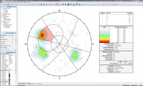
Dips is designed for the interactive analysis of orientation based geological data. The program is capable of many applications and is designed for the novice or occasional user, and for the accomplished user of stereographic projection who wishes to utilize more advanced tools in the analysis of geological data.

It helps you determine the likelihood of rock failure in sandstone reservoirs.
Search an anatomical terminology from an image or an anatomical location.

is a fully interactive visual software system for unified deterministic

Drag and drop the country names of United States correctly onto the map.


Comments
Facebook comments